
California or Bust: A Young Pilot’s First Solo Cross-country Adventure
“N572DS is cleared to the Papa Romeo Charlie airport via runway heading, direct VINCO, join V107, then Papa X-ray November, join V113 to PRIEST, then as filed. Climb and maintain 5,000, expect 11,000 one zero minutes after departure. Departure frequency 121.3, squawk 3757…read-back correct.” Gauges green, airspeed alive. “N572DS I have an amendment to your clearance, advise when ready to copy. N572DS is cleared to the PRC airport via direct Shafter, join V197, then as previously cleared…read-back correct.”
If any of that paragraph seems rushed, hurried, confusing, or otherwise unclear, then it had the desired effect. I was equally confused, only I was in the airplane leaving a busy airport with a Boeing 737 or two waiting for me to get out of the way. Some of you may have heard about the 21-year-old kid who decided to fly a Diamond DA40 solo from Indiana to California. Please allow me to introduce myself. My name is Cody, and my passion is flying. I fell in love with flying on my first flight in the winter of 2014 and earned my private pilot certificate on March 29, 2016, with 63 hours under my belt. On February 19, 2017, the ink dried on my instrument rating with about 190 flight hours. On March 11, 2017, I departed Smith Field Airport, bound for the first of five planned stops on an epic cross-country that would, if all went according to plan, find me in KSJC, San Jose International Airport.
The first leg of my flight ended in a diversion to KTBN in south central Missouri. My planned destination was only one-half-mile visibility with fog, snow, and 300-foot ceilings just before I would have begun the approach. The onboard XM weather confirmed what I saw out of the crystal-clear canopy. I was flirting with snow storms south of St. Louis, so I looked for an airport that was shown outside of these unwelcome meteorological events. Sure enough, TBN was comfortably VFR, so I stopped for some fuel and lunch just shy of the 4-hour mark. Departing TBN, I found the clouds were lower than any of my four prior briefings had shown, but the temperature was +4°C. “Proceed with caution,” I thought. In the clouds at 6,000 feet, the OAT dropped to 0°C.
Not wanting to add ice accumulation in a non-approved airplane to my experience, the situation called for a diversion to Springfield-Branson International Airport. The clouds weren’t forecast to lift until evening, so I decided to catch an hour of sleep, review my planning, and grab dinner. Kicked back in a recliner with laptop open is how I passed most of the evening. By studying the weather patterns and forecasts along my route, it seemed the clouds were going to lift within the next hour and would stay away until early morning, but they were forecast to return with a vengeance later. This caused me some internal time pressure to leave while I could, but the next destination airport along my route was only attended dawn to dusk. It was well past dusk, and I wasn’t assured that I would be able to get fuel upon landing. So should I stay in the comfy recliner and risk a 1-day delay, or should I continue my route and risk getting stuck camping out under the stars in the plane on a desolate ramp in the middle of Nowheresville, Oklahoma? This seemed like one of those aeronautical decision-making scenarios that we learned about during flight training. I was low on sleep, so I decided that I’d rather be well rested and behind schedule than strung out but on time.
I couldn’t sleep, try as I might, so I eventually made the decision to press on. KAMA, Amarillo International, was not far out of my way, and it was attended around the clock. A Hobbs time of 3.5 and a very humorous center controller later, I landed at Amarillo to refuel and check weather. The weather along the route looked good, and I was still wide awake and alert, so I continued on to KABQ, Albuquerque International, which was one of my original planned stops and only about two hours from Amarillo. I descended over the mountains into KABQ around 4:30AM local time and decided it was time to put the trip on pause and inspect their pilot lounge for a few hours, regardless of how I felt. Hours later, I borrowed the crew car for breakfast, hopped back into the airplane, and departed for KPRC, Prescott Airport, in northern Arizona. If any of you decide to take a trip like this, be advised that there are approximately four airports available for the entire 3-hour flight between ABQ and Prescott, and very little to look at. Nevertheless, the beautiful airplane that I helped reassemble two days prior was running great, so I landed without excitement at PRC. Thirty minutes later, I was taxiing for departure to KBFL, Bakersfield, California, and noticed that the airplane would not run unless I leaned it out by at least 30%. I attributed this to the 6,000-foot density altitude and checked the engine with a full-power run up, which confirmed the abnormal, but proper, mixture setting.
Bakersfield provided the first of many breathtaking scenes during the trip. The mountain tops surrounded a basin filled with a white, wispy fog. It appeared as though the fog was trying to crawl its way up the mountains, but whimsically trailed off prior to reaching the top. It was so spectacular that it almost overshadowed the looming thought of approach minimums into the area, available alternates, and fuel reserves. The ATIS at BFL was saying clear skies and over 10 miles of visibility, so I had to assume that it was a haze layer, rather than fog. Be that as it may, I could not see any of the city, let alone the airport, so I requested the ILS. I discovered that even the ATIS is sometimes inaccurate, and I finally managed to get the airport in sight at 3 miles out. Bakersfield gave me my first-ever departure procedure due to the haze, which got me above it and allowed me the pleasure of some amazing scenery (much appreciated after the three hours of nothing that I experienced between Albuquerque and Prescott).
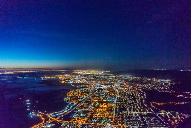
“NorCal Approach, Diamondstar 572DS.” I waited five minutes. “NorCal Diamondstar 572DS.” Nothing. Switching back to Bakersfield (never change your backup frequency until you’ve established communication on the new one), I let them know that I couldn’t get NorCal. They assured me that sometime within the next 10 minutes I would be able to pick them up, but if I couldn’t, I should call them back again. Sure enough, they were correct. Oddly, this was the third time during the trip that I had communications issues, and not all of them were in the mountains. Arrival into SJC involved delay vectors for a 737 that was coming in ahead of me. Being that I was only 10 miles from my final destination, I was much less concerned with time. After five minutes on my assigned heading and descent, I was approaching a mountain, and the controller had not said a word to me. I waited, thinking, “that’s a big mountain, looks pretty solid too.” I tentatively inquired, “Umm…approach, 2DS has terrain ahead that I’m not going to clear at this rate. Am I going to get another vector?” I was met with a quick reply, “Turn right from 060 to heading 270 and join the localizer.” Great. No more mountain, and look at that sunset! I maintained cruise speed until the final approach fix and asked if there was anybody behind me. “Affirmative, there is an Embraer on 5-mile final.” And keep my speed up I most certainly did, until short final when I chopped the power and deployed the flaps. After landing, I contacted ground and received taxi instructions to Atlantic Aviation. “2DS did you say you were going to Atlantic?” the voice from the radio inquired. “Oh boy,” I thought. “Yeah…did I miss it?” Oh yeah. I did. “My apologies, I’m not quite used to parking next to such large, shiny planes.” I was parked between a G650 and a Citation 5.
The return trip was mostly uneventful, with the only adverse weather occurring upon descent back into KSMD. With my westbound experience and the slight tail wind, I was able to cut down on the number of stops on the return trip. What were some things I learned on such an epic trip? The US is huge and different areas have significantly different challenges! I noticed Bakersfield was still covered in haze. Prescott’s density altitude was 6,000 feet again, and Albuquerque was still beautiful to fly over at night. Springfield-Branson International has the best recliners of any pilot lounge I have been in, as well as complimentary blankets to borrow. It seems that flying in the Midwest during the winter months is your best bet for encountering adverse weather. ATC is much friendlier than they sound. Communication issues can be normal and don’t have to be frightening. The air truly is smoother at night, and generally the controllers are much more free to joke and have conversations at that time. Always have a plan for everything, and always be willing to change or even abandon it. Keep your eyes an hour ahead on your route. Write everything down. If you’re unsure, just ask. If you’re pretty sure, just ask. Relax as much as you’re able without compromising safety. Research every aspect of every step of your route, including all the airports within 20 miles of the route, the safe altitudes, the weather and patterns, the winds, etc. XM radio is a godsend, and iPads may not be a technical requirement, but for a trip like this, they are most definitely a practical necessity.
I spent about two weeks planning my route, researching airports, getting briefings (standard briefings for the NOTAMS and weather to get a feel for the patterns), checking the plane (very, very thoroughly), planning the route again to check for consistency in my thought processes, etc. Even with this exceptional level of planning, I had to significantly alter the route due to a weather system that was not forecast. Even so, I still had the original route with me to use as a guide in making further decisions, and I actually joined back up with it in ABQ and followed it the rest of the way to the destination. All the prior briefings for NOTAMS left me with no surprises during the trip, but I did call for a fresh briefing just before each departure, just before filing my flight plans. Even if you don’t want to fly in IMC, I would highly recommend getting an instrument rating if you want to travel more than a few hours from home, which I would also recommend. During a 9-day period, I gained 36.6 hours of flight time, which except for 2.3 hours of sightseeing under SFO class B in the Bay area, was all under IFR flight plans. I’m now a 226-hour pilot ready to begin my commercial flight training and then a career as a professional pilot.